Saturday 27 December 2014

Extreme North

The Arctic north of Russia is a vast amount of territory to the north of the Arctic Circle, which stretches along the whole of the Russian Federation both in Europe and Asia. In Russian literature you can also find a definition «Krayniy Sever» [Extreme North] and it includes such regions as the Kola peninsula, the Yamal peninsula and the city of Norilsk (which I already looked at in one of my previous posts). 


The region rich in oil, gas, gold, coal and diamonds for years have been dominated by an approach which can be formulated as follows: «the more we take from the Arctic, the better». Such approach eventually led to the conflict between industrial civilisation and Arctic ecosystem, which Russia is facing today. 

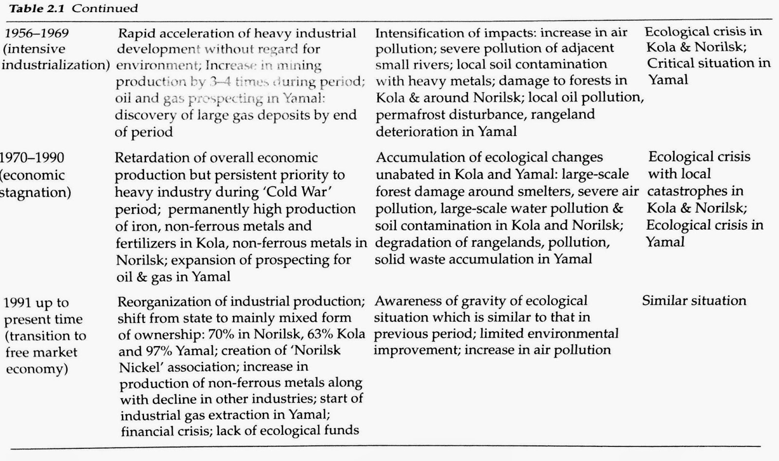
Throughout the history of the world the human impact on the Arctic North remained insignificant, but this has changed in the 20th century with the beginning of Stalinist industrialisation. The «North» was already playing a very important role as a resource base during the Soviet period, however, with the fall of the communism it’s importance only increased. Currently, it’s territory accounts for 80% of all Russia’s oil, 90% gas, 90% nickel and gold production, in addition to a a great share of mineral fertilisers and timber. 

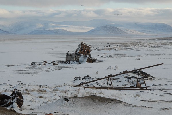
The intensive economic development of the Arctic North, which has been responsible for the degeneration of the environment is associated with the intensification of industrial production during the «Cold War» period. The Russian Arctic North has been affected by various activities ranging from mining, non-ferrous Metallurgy to oil and gas extraction. 

Air Pollution

Chemical and dust pollution is mainly the result of mining, non-ferrous metallurgical industry and oil production. Annually, about 6.5 million tonnes of pollutants are emitted from stationary sources into the atmosphere over the Russian Arctic, which account for 18% of all Russian emissions. The range of emitted pollutants include highly toxic contaminants as benzopyrene, lead, vanadium, chromium and mercury.

Lately, mechanical disturbance of the ground and dust pollution become more significant, which come from the transportation of of toxic dust from quarries. The toxic substances reach the environment affecting vegetation, soils, surface and ground waters. Annually 30 million tonnes of waste rock is produced by the Apatity combine, located on the Kola peninsula. It has been estimated that after 60 years of it’s operation, the impact area of pollutants reached 300 km2. 


The Russian Federation is one of the world’s top five energy producers. It's oil and gas industries in West Siberia annually burn over 19 billion m2 of associated gases, releasing hydrocarbons, heavy metals and carbon dioxide into the atmosphere.


Water pollution


Soil contamination

Between at least 700,000 to 840,000 hectares of polluted soil in West Siberia Region is polluted by oil, the area much larger than indicated by the government. It  has been caused largely by oil pipeline and well spills, but also by oily muds, drilling and production waste, chemical waste disposal and leaking storage places.


The toxic effect of oil spills in the Extreme North is worsened by the fact that the region is layered with impermeable permafrost, which means that pollutants are absorbed by ice and snow and remain in the environment for centuries. 


The economic activity in the North is often associated with damaging the soil cover and permafrost environment. This results into formation of thermokarst lakes and water logging, which can potentially be a source of significant carbon emissions during global warming.


Vegetation

The Kola peninsula, perhaps the most economically developed area of the Russian North, is covered with over 100,000 hectares of «anthropogenic desert». The trees in this zone are not able to survive due to high sulphur dioxide emissions, so the forest border line is moving to the south each year, giving a prospect of turning the peninsula into the rocky tundra in a few decades. 


Tuesday 23 December 2014

The World's Most Radiated River [in Photographs]

I would like to share with you an absolutely tremendous picture story by Robert Knoth, a freelance photographer, who is also an author of "Certificate no. 000358", a book which documents the impact of nuclear disasters on people in the former USSR.

You can find more photographs by clicking the link above..

Kostya has Down syndrome, is sick often and had to have his fingers separated through surgery. His mother Ludmilla swam in Techa River when she was young, the village was contaminated by the explosion in 1957.
Alexander has a mental handicap and lives in an orphanage. Many children in the region are born with mental problems due to the high doses of radiation their parents received. Few parents can financially support their sick children.
Karl Marx Street in Muslumovo. This is one of the main streets of the village close to Techa River. The street is almost totally abandoned because radiation levels are too high.
"I don't like to go to school, because the boys call me bad names. I would like to court the girls, but they shun me and donít want to go out with me. I hope I will not have children who look like me"


Friday 19 December 2014

The World's Most Radiated River

«Usually when you are looking at an environmental catastrophe, you know it. Disasters have the look and feel of the natural order disassembled. In my mind, disasters should smell, smoke, or produce ugly scars. Yet nothing was out of place along this inviting little stream. The air was fresh. Swallows darted back and forth over the current. The afternoon was turning hot and, as if siren were calling me, I had a desire to slip down and run my feet over the smooth stones in the river bottom. There were no fences or warning signs to stop me.I had to remind myself that I stood before the world’s most radiated river»

Kate Brown 

The first Soviet industrial reactor was constructed in Chelyabink oblast near the lake Kyzyl-Tash and began it’s operation back in 1948. Plutonium that was produced by this industrial reactor was used for construction of the first Soviet atomic device. Later, a number of other plutonium production reactors were constructed at the Production Association «Mayak», which is now one of the biggest nuclear facilities in the Russian Federation. 


The decision on it’s construction was made back in 1946, involving around 45,000 of construct builders and prisoners into this secret project. An area of almost 100 km2 was surrounded by the borderland and cordons of soldiers and it wasn't even shown on a map. Perhaps, this was the reason why the Kyshtym accident, one of the worst nuclear disasters in the human history, was kept unknown for almost 30 years. However, this is a different story and today I would like to shade a light on the tragedic fate of the people from the shores of Techa river.

Techa River warning sign


Warning sign forbidding picking berries and mushrooms in this area


The Techa river is about 240 km and at the time of radioactive pollution there were 41 rural settlements along its riverside with a resident population of 28,000. Inhabitants of these settlements were not informed about deadly discharge of radioactive wastes in the river and kept the normal habit of life. They used water from the Techa river as drinking water, they cultivated their contaminated pieces of land and used contaminated flood lands as a pasture for their cattle.

Two years after beginning of radioactive wastes discharge into river, medical health checks of the residents started. They demonstrated that a majority of inhabitants experienced changes in their hemopoietic, immune and other systems. Furthermore, there were several hundreds of Mayak facility workers facing the same health conditions. They complained about headaches, sharp pains in bones and joints, constant weariness and loss of weigh. Medical professionals had no choice but to define a new condition that people were developing, so this led to the introduction of chronic radiation sickness (CRS), a syndrome which is caused by extended exposure of the organism to the low doses of radioactive isotopes.

Radiation victims


22 years old Raisa committed suicide as she couldn't cope with the pressure from cancer disease. Muslumovo. 
Unfortunately, the residents have nowhere to escape from this radiation zone as ever since Soviet Union collapsed, Russian government failed deliberately to resettle Muslumovo residents. In 2008 some lucky residents were resettled, but only as far as to the other side of the river, which doesn't seem to be much less radioactive. 
Kate Brown, the author of «Plutopia: Nuclear Families, Atomic Cities, and the Great Soviet and American Plutonium Disasters», believes that residents were kept together as the valuable base for future medical research

A man walking from his old house to his new house, which is only 1.7 km away
The Mayak Production Association continues functioning today, however, releasing it’s waste into Karachai lake instead of Techa river and this means that the tragedy may repeat one day. Those poor souls damaged by the radiation from the river will never recover, and so many generations of their children. 

Here is a poem written by the kids from one of the affected villages:

Посылает Маяк не спасенья лучи:
Стронций, цезий, плутоний - его палачи.

(«Mayak» is not sending us the lights of salvation,
Strontium, cesium, plutonium - it’s deadly executioners)


Friday 12 December 2014

Norilsk: Russia's most polluted city. Interview with photographer Elena Chernyshova

This is a short interview with a Russian documentary photographer to give my readers some feeling of what is it like to be living in one of the most polluted places on Earth..


Friday 5 December 2014

The Air

«What is a Soviet citizen breathes as he watched with a sense os superiority a TV program about the suffocating Los Angeles smog?» 
Boris Komarov

Back in the former Soviet Union, the government promoted the economic development at all possible costs. On the eve of collapse of USSR, the country produced the same volume of air pollution as United States, however, with 2 to 4 times lower economic output. Although the level of industrial pollution has decreased since 1990s, Russia’s air is still among the most polluted in the world. 


The Soviet environmental protection agency regarded air pollution as the biggest ecological threat to the country. Starting from 1980, the Soviet meteorological service began recording the volume of atmospheric emissions coming from the two main sources: stationary sources (industrial enterprises and power plants) and transport (cars). According to this data, the total amount of air pollution in 1989 was 94 million, with more than half of this volume coming from stationary sources.


The pollution has been uneven throughout the country and some of the regions experienced heavier pollution than others. 

The Russian Arctic region is the home of developing gas extracting industries, as well as the largest nickel and copper smelting plants and coal mines in the world. Tundra and northern taiga are occupied by enterprises that produce paper and pulp, aluminium plants, oil extracting and processing industries, industries extracting gold and diamonds. 

Among the cities in northern Russia, the leading source of pollutants is Norilsk, which accounts for over 2 million tons of different toxic emissions per year. The city was founded back in 1935 as a settlement for the Norilsk mining-metallurgic complex, today, the largest one in the world. According to the indicator of relative danger from release**, Norilsk takes the first place in Russia.


The location of the plants around Norilsk means that residents always have to breath in the emissions coming from one or another side of the city. In this way, the northwestern part of the city especially suffers from copper plant releases when the wind blows from the west ; the south-eastern part is at risk when the wind blows from the south. The reason behind this odd construction plan lies back in 1930s, when the only people who lived in Norilsk were the prisoners from the GULAG labour camp and the government wasn’t worried about public enemies’ potential health problems. To make it even worse, such a thing as «ecology» simply didn't exist for Soviet government at that time. 


Sulphur dioxide and aerosols of heavy metals (nickel and copper) are the main components of atmospheric emissions from nickel smelters, which present a threat to forest ecosystems. For instance, sulphur dioxide emitted from the nickel mining combine is a cause of acid rains which killed all the vegetation within a 120 kilometer radius of Norilsk's facility. 


Vegetation Damage Around Norilsk Facility


The impact of air pollution around the city on humans is even worse. Norilsk is one of the 11 Russian cities with the highest rates of disease among children under 14 due to air pollution. 


The Russian government recently accepted an offer from an association of Swedish and Norwegian companies for upgrading the facilities of Pechenga Nickel, which would allow to cut sulphur dioxide emissions by 95%. However, there is no way to prevent the pollution of fragile subarctic ecosystem unless the management of the Norilsk facilities is willing to invest their revenues in the company instead of diverting them to their own pockets.


Footnotes:

*Standards for individual pollutants in the atmosphere were expressed in terms of maximum permissible concentrations (predel’no dopustimaya kontsentratsiya in Russian, or PDK) tolerated for human health. 

** The ratio of the released amount to the maximum allowable concentration (MAC) of the released chemical in the air

Friday 21 November 2014

Making Rivers Run Backwards


Large-scale redistribution of water resources from the north to the south of Russia was firstly proposed over 100 years ago. Average annual river flow on the territory of the former Soviet Union is estimated to be over 4700 cubic kilometres. However, the distribution of resource didn’t correspond with the distribution of population, agriculture and industry in USSR. 

Most of the river flow travels though the economically underdeveloped, empty land in the northern and eastern regions of Russia and then «uselessly» empties into the Arctic Ocean, while densely populated south, which also consists of former Soviet Union republics and region’s two biggest cotton-growing nations (Turkmenistan and Uzbekistan), remains arid.

The Potential Scheme of River Diversion
The first planning work on water redistribution project started back in the 1930s, and was carried out intensively in the 1970s, up until it was abandoned in 1896 by then-Soviet President Mikhail Gorbachev due to environmental concerns. The major rivers such as Pechora, Ob and Irtysh all were supposed to be a part of the Siberian river reversal. The project was not only supposed to solve irrigation problems in Central Asia, but also save the shrinking Aral and Caspian Sea.

Aral Sea

Even though most of the Siberian river reversal project never left the drawing board, one such plan to divert the Pechora and Kama rivers toward the Volga and the Caspian Sea has been attempted in the 1971, a canal to be dug using 250 nuclear explosions. 


The Siberian river reversal project met a lot of criticism over it’s course of development and still does today. 


“Redirecting even five to seven percent of the Ob’s water could lead to terrible, long-lasting changes, including the destruction of fishing, harm to the delicate Arctic, and more.” 

A. Yablokov
Yablokov said the plan, which would could cost $30 billion at a minimum, might change the climate in the Arctic and elsewhere in Russia, destroy many of the Ob’s downstream ecosystems, and ruin thousands of acres of fertile land. He also mentioned about  potential leakage in the canal, which could lead to a massive loss of water before it even reaches it’s destination, turning vast areas of western Siberia into a swamp. This means diverting rivers would be wasteful, unless Central Asia adopt more efficient irrigation techniques.

Friday 14 November 2014

Aral, The Lost Sea

I would like to share the video I recently found on Youtube, when I was researching on the previous topic. This is a documentary film directed by Isabel Coixet from 2010. It was produced for the We Are Water Foundation, telling the story of those people who were born beside the sea and one day lost it.

"There is an old legend that says that the Aral has dried three times.. Three times it's dried and three times it's come back. Three times.. Some day the sea will come back".

Thursday 13 November 2014

Aral Sea

The ship "graveyard" in Karakalpakstan

Even though the name of this blog suggested that my analysis will be based around Russia only, the case study of Aral sea could not be ignored as it is a terrifying representation of land and water management combined together in the Soviet Union. Therefore, I’ve decided to extend my geographical constraints for today and to have a look at the lands of Kazakhstan, Turkmenistan and Uzbekistan, all of which are former USSR countries. 

The Aral Sea, once the fourth largest inland water body on earth, has become well-known to the world as one of the planet’s worst environmental disasters. It shows how the lack of long-term planning in chase of economic benefit can ruin the ecosystem and harm the society. 

The lake has been steadily shrinking, starting from the early 1960s, when the Soviet government decided to diverge two main rivers that fed the Aral sea, in the attempt to boost cotton production, which they used to call «white gold». Eventually, the Sea has shrunk by approximately 65-70% in volume and 50-60% leading to the extinction of various species and the change of region’s climate. 

The Aral Sea timeline:


Before 1960: 
The Aral Sea Before 1960s
1960s:
  • Water is drawn off at numerous points along the Amu Darya and Syr Darya in Turkmenistan, Uzbekistan, and Kazakhstan on their way to the Aral Sea. As much as 20 to 60 cubic kilometres of water is going to the land, so the Sea only gets 20 cubic kilometres in the most favourable years. At the same time, the water evaporates at the 33-36 cubic kilometres per year. 
  • There is not enough inflow to sustain the same water level, the Aral sea begins to shrink.

1970s:

1980s:
The Salt And The Toxic Chemicals Accumulated At The Seabed

1990s:
  • The water level dropped by more than 15 meters, the sea has shrunk to half of it’s normal size, causing the sea to split into two: "Little Aral" to the north fed by the Syr Darya, and "Big Aral" in the south fed by the Amu Darya.
  • The Aral Sea is fast becoming the Aral Desert. This leads to the change of climate - the summer heat has become hotter and drier and winters are more severe. 
  • The intense use of fertilisers and pesticides has contaminated groundwater supplies. At the same time, the settlements along the lower reaches of the Amu Darya in Karakalpakistan must draw up to two- thirds of their drinking water from the river. 
  • The region has turned into «slow Chernobyl» with increased infant mortality rate, typhoid fever, tuberculosis and viral hepatitis outbreaks.  
  • The Aral Sea’s surface is only 17,160 km2 . The five-fold increase in salinity has killed most of it’s flora and fauna.

2000s:
  • The South Aral Sea has been abandoned as the Uzbekistan government is more interested in extracting oil from the drying seabed.
North Aral Sea Rescue Program

The sad story of the Aral Sea is now repeated in other parts of the world. For instance, disappearing Lake Chad in Africa and the Salton Sea in California.

"Sorry, Aral [region]!"


Do you have any questions? What topic would you like to be covered next? Comment below.


Saturday 8 November 2014

The Land: Chemicalization of Agriculture

Pesticides tend to be the most serious problem in those countries that have a strong agro-chemical industry as well as agricultural and forestry sectors that are characterised by monocultures and a goal of high labor productivity, which is a precise description of what was happening in USSR. 


"Sweetcorn is a source of abundance"
The Soviet leaders strongly promoted «the chemicalization of agriculture», which was believed to make the USSR self-sufficient in agricultural production. In 1965 the country produced 31.2 million tons of fertilisers, and in 1975, this number already reached 90 million tons. In 1986, pesticides were used on 87% of all arable land in the USSR. 


It is known that pesticides have been frequently misused and overused in the USSR, which often led to accidental kills of various animals. For instance, in 1979 the misapplication of zinc phosphide killed 169 geese at a collective farm near Rostov. The similar reports have been appearing all over the country at different times.

One of the main dangers of pesticides is their ability to build up to significant concentrations over time and remain in the environment for many years. From 1950 to 1970, more than 20,000 tonnes of DDT were used annually in the Soviet Union, pesticide known for it’s high potential to bioaccumulate, especially in the body fat of higher mammals. It is hazard to environment, both to those areas where it has been used directly and the regions thousands of kilometres away. Although there is still lack of knowledge on the potential harm of DDT to humans, some studies suggested an association between DDT and certain cancers.


Despite the official ban in 1970, DDT continued to be used until late 1980s. Following the fall of communism in 1991, many pesticide stores were left unattended and have since collapsed, threatening environment. An inspection by the local agency of Tomsk in 2002-2003 discovered 3 tons of DDT stored in local hangars, with reports that some DDT had leaked out into the surroundings.

The problem with intensive use of highly toxic pesticides in the former Soviet Union is that after the state has collapsed, Russia has lost the trace of where farm pesticides have been stored, which are estimated to exceed 250,000 tonnes. This means there are large amount of health-threatening toxins buried around the country still to be detected. 


Monday 3 November 2014

The Land

Like other natural resources in the Soviet Union, agricultural land suffered heavily from the extensive nature of its exploitation. 
Many problems can be traced to the Virgin Lands Programme instituted in the 1953 by Nikita Khrushchev. Not many people know what Nikita Khrushchev’s wife has died young from starvation in the terrible famine in 1921, which might have left a lifelong concern for food and agriculture in his mind over his career at communist party. 
Virgin Land postcard
Dissatisfied with the low yields on existing farmland, Khrushchev initiated a drive to open up vast new tracts of land in order to alleviate the food shortages plaguing the Soviet populace. 
During it first two years, the Virgin Lands Programme recorded with positive and negative impacts. Grain productivity sharply increased, but soil degradation processes, especially wind erosion on the sandy lands, cleared of their natural vegetation. Most of the virgin lands were grassland of marginal quality and not allowed to lie fallow for long periods.


Though the program was abandoned, as it hasn't proved to be very sustainable, these marginal lands continued to be cropped continuously as farmers were under constant pressure to boost output. As a result, an average of 30–50 percent of the humus was lost, turning parts of southern Siberia and northern Kazakhstan into a virtual dust bowl.